Why don’t they just go to the light a block away?
Ever wonder why a cyclist or a pedestrian tries to cross at an uncontrolled intersection? Maybe you slow to let them cross. Maybe you honk when they try and move forward forcing you to stop. I am talking about busier streets in the city. Why do people cross these where it is unsafe? Are they crazy? No. Human nature is to take a direct route. Maybe they live across the street. Maybe they are going much farther. No matter the reason, it is dangerous.
Often one car stops in the curb lane but the car coming up in the middle lane doesn’t stop. Sometimes one lane stops, but the other lane doesn’t. Sometimes a left-turning car is focused on finding a break in traffic, and not the bike, person, or other car trying to cross. Add poor lighting, wide curb radii, and line of sight obstructions, and accidents are inevitable. So what can we do? Or more importantly, who is responsible?

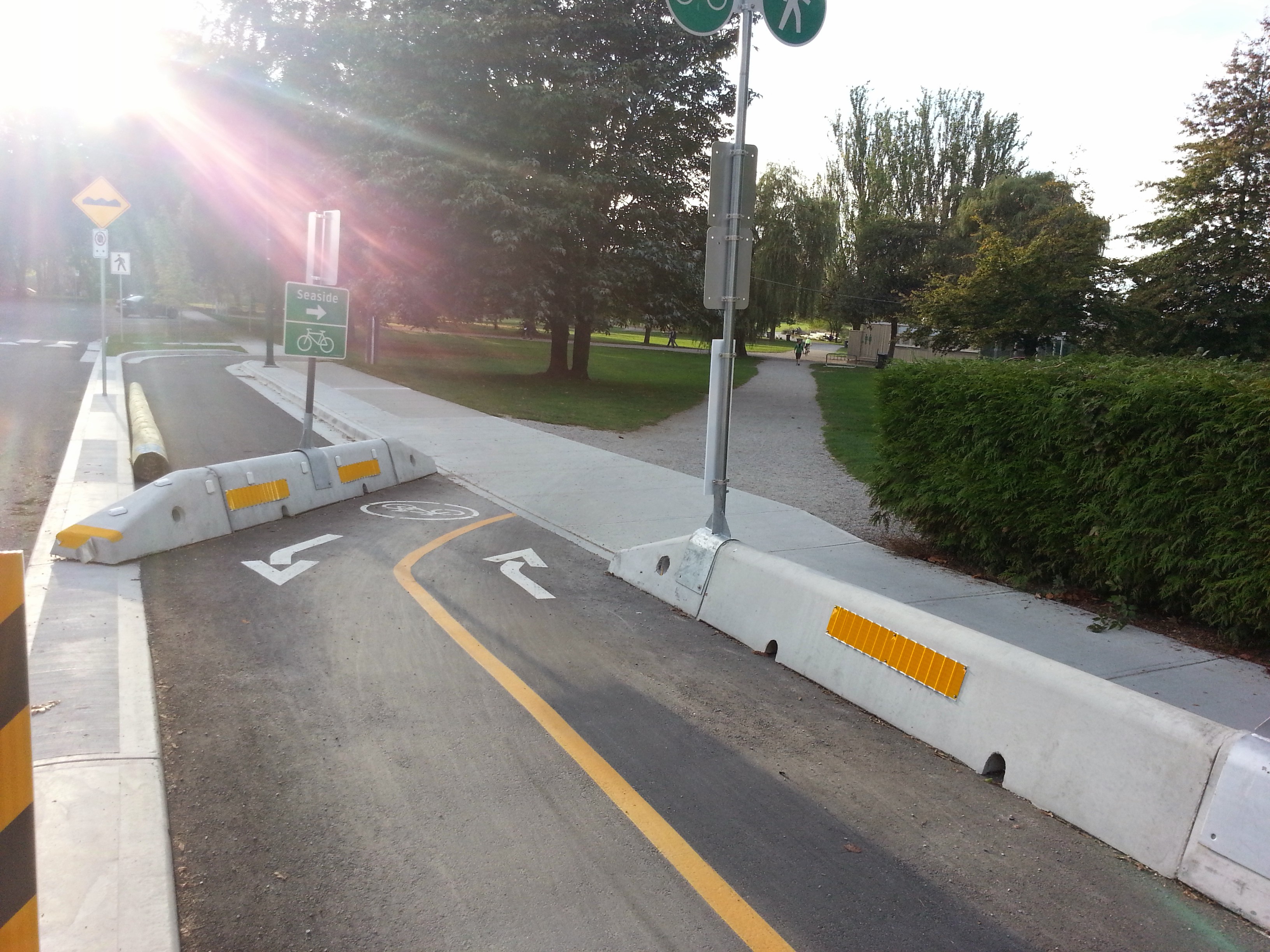
Wide crossing with large corner curb radii.
I blame bad design based on incorrect priorities Take W12th from MacDonald Street in the west to Boundary Street in the east. This route is consistently used to bypass the busier West Broadway by cars. The Broadway corridor is a destination for all the residents along both routes. The high demand for crossing from south of W12th to the destinations in the north along this corridor is a recipe for accidents and a disincentive for walking and biking.
MacDonald to Arbutus is low rise residential with a a school. There only two pedestrian controlled crossings. Moving along, after the high school is a large park with one uncontrolled crossing. This park zone speeds are consistently ignored, with the wide open unobstructed street. After the park, there is another controlled light and the Arbutus intersection. If a car has a green on both of these intersections, it will be averaging above 50km/hr. This is exacerbated by racing around left-turning vehicles in the centre lane to beat the light change.
This issue repeats for the rest of the strip. Cars continuously maintain speeds over 50km/hr except where lights and congestion prevent the possibility of doing so.
So where is the design flaw?
Parking, Curbs and crossings.
When parking is allowed on W12th, the traffic speeds are lower on the entire route. The observed speeds are near the speed limit. The parked cars reduce the route to one lane in each direction. It is not only the proximity to the parked cars, but also the reduced decision-making that slows the traffic. When there are two lanes, drivers continuously are trying to choose the faster lane. This is essentially a race car mindset. If you are always passing or trying to keep ahead, you are always speeding. With only one lane, driving decisions become simplified to intersections: turn or stay.
Curbs and crossing also play a role in bad design. When the curbs have generous turning radii, pedestrians and cyclists have to move into the curb lane to see and to be seen. There is also the issue with a cyclists arriving behind a right-turning car at these large radii curbs. The car is already positioned to the right so the cyclist is forced to go into the middle of the side street. This is dangerous for several of reasons. The car turning miscalculates and reverses as the cyclist moves behind it; the cyclist is blocked by the car from the view of on-coming traffic from the right; and, the cyclist is in the way of a left-turning car that turns into the side street.
Good curb and crossing design is about visibility and positioning. Bringing curbs out so that crossing pedestrians are visible to traffic, narrows the space needed to cross and increases their visibility. Reducing the curb radii is better for cyclists both for visibility and for positioning them relative to traffic on the side street with the added bonus of having the curb to lean a foot against. Reducing the curb radii slows the speed cars can turn the corner, but it also forces longer vehicles to move into the other lane of the side street to make the corner. When crossings are better designed, drivers, cyclists and pedestrians have a more reliable expectation of how and where crossing take place increasing the safety.
My recommendation:
The City should have controlled crosswalks for every block on W12th. This would correspond to West Broadway and help connect to the off-Broadway bike route. W12th is designed for speeding and creates an unsafe environment for all modes. Overall, the City needs to consider upgrading the curbs and crossings when they perform the sewer/storm drain separation. Is this expensive? Yes. But, if we want to get more people to walk and bike more, we need to create safer streets. The City has outlined its mode priorities, but has failed on this street to implement them. Simply put: if these safety improvements lead to traffic moving at the speed limit, and increase walking and cycling, why aren’t they being made?